TRAVEL

Monument Valley & More

The famous Mittens at dusk

The famous Mittens at dusk

MONUMENT VALLEY:

Monument Valley, that ever iconic symbol of the Wild West, has always represented for me the rugged and unexplored frontier, what’s possible for the curious, and the reward for the seeking, the real diamond in the rough. The real secret though? There’s so much more to do in this area. But let's start at the beginning.

Okay, so you want to go to, but you need to know where to stay and what to do. No problem. 


WHERE TO STAY: THE VIEW

http://monumentvalleyview.com/

Grab a room at The View! There is no place closer than this for your access to Monument Valley. Rooms here are reasonably priced, especially for the views, (you can see Monument Valley from your room!) and it includes a complimentary breakfast. The restaurant provides local cuisine and I recommend getting a Navajo Taco. A gift shop is attached to the restaurant if you're in the mood for grabbing a souvenir, a beautiful piece of Navajo jewelry or pottery. How much for a night? Plan on spending between $100-$200 a night. Rooms fill up fast so book your room a few weeks in advance. 

The View

The View

WHAT TO DO: GO FOR A DRIVE

So you've paid a small entrance fee and made it to Monument Valley. What next? GO FOR A DRIVE and see the sights. Right next to The View Hotel is a 17 mile looped road for your viewing pleasure. A compact car will do, but be prepared to drive slowly on a dirt road with some potholes. Along this route you will see much more than the Mittens, a myriad of rock formations and valleys that give you a much better appreciation for the depth of the valley. How long does the loop take? Pack a lunch and plan on spending a few hours by stopping at the many sights along the way. Maps are available at the entrance fee station.


BUT WHAT ELSE IS THERE TO SEE?

I'm glad you asked. SO MUCH MORE! Here's a small list below to get you started.


VALLEY OF THE GODS:

Looking for a more rugged experience? How about pitching a tent along Valley of the Gods road? Here, you'll beat the crowds and be even closer to the large monoliths rising up above you. Give it a go. You won't be dissapointed.

IMG_6776.JPG


GOOSENECKS STATE PARK:

Wanna see something wild? Take a quick trip over to Goosenecks State Park to see the meander of the San Juan River. It's a truly spectacular sight.


IMG_0242.JPG


MOKI DUGWAY:

To see a breathtaking sight of the Utah/Arizona land in which you'll be roaming about, take the steep, unpaved but graded switchbacks of Moki Dugway. When you get to the top, take a moment and pull over, and enjoy the sights below you.

IMG_0362.JPG

WELL...

What are you waiting for? GO ADVENTURE!

Monument Valley at sunrise

Monument Valley at sunrise

Grand Canyon - RIM TO RIM TO RIM

Looking into the Grand Canyon from Bright Angel Trail

Looking into the Grand Canyon from Bright Angel Trail

AN OVERVIEW:

The Grand Canyon may just be one of the most iconic examples of grandeur in nature. For the more daring adventurers, perhaps one of the best ways to see just how big it is would be to try hiking the Canyon from Rim to Rim to Rim. Of course this hike could be modified in any way, shape, or form. A more popular version of this is simply hiking Rim to Rim (South to North) and placing a car at both ends for pick up. Yet another option is hiking a loop of the South Rim from Bright Angel to South Kaibab, with a park shuttle able to take hikers from the end of the trail to their car.

RIM TO RIM TO RIM - THE ROUTE:

Okay, so you've decided to do the BIG hike. Here's what to expect: 50 miles over rock, dirt, steep cliffs, and winding canyons. While some hikers attempt this hike in one day, I do strongly recommend to do this over two or three days. The route can vary on which Rim and which trail you decide to begin your hike. I will suggest here a route and agenda that worked well for me.  

Day One: Camp at Mather Campground on the South Rim. Tent and car camping is $18 a site. At Mather Campground you are just a few minutes drive to Bright Angel Trailhead.

Day Two: Park car at Bright Angel trailhead and begin the epic journey. Take Bright Angel to North Kaibab. You will pass the Colorado River and then Phantom Ranch (and also many other campgrounds including Cottonwood). Camp at the North Rim. No backcountry permits are needed if camping is done on top of the Rims, but is needed if camping in the Canyon.

Day Three: Hike North Kaibab to South Kaibab. Take the park shuttle from South Kaibab trailhead to the trailhead of Bright Angel to pick up your car.

*Note: You can approximately count on 25 miles of hiking a day from Rim to Rim. It should take an average hiker of good shape and a decent pace from 10-14 hours of hiking to go Rim to Rim.

WEATHER AND WATER:

Weather is going to be a determining factor in planning your hike. Spring and fall months are gonna be your best bet when temperatures are much cooler. DO NOT ATTEMPT this hike in summer months, or if you do, use extreme caution.

There are water stations along the trail to fill up, however, there is NO WATER available along the South Kaibab trail (please plan accordingly). I carried 4 liters of water on me at all times and I was able to refill at each water station. I had no issues, but remember that everyone is different when it comes to water intake. Having a source of electrolytes is also very important. I suggest Gatorade or Propel packets to mix in water. Coconut water is also a great source of energy. 

VIEWS

Sunrise at Bright Angel Trailhead

Sunrise at Bright Angel Trailhead

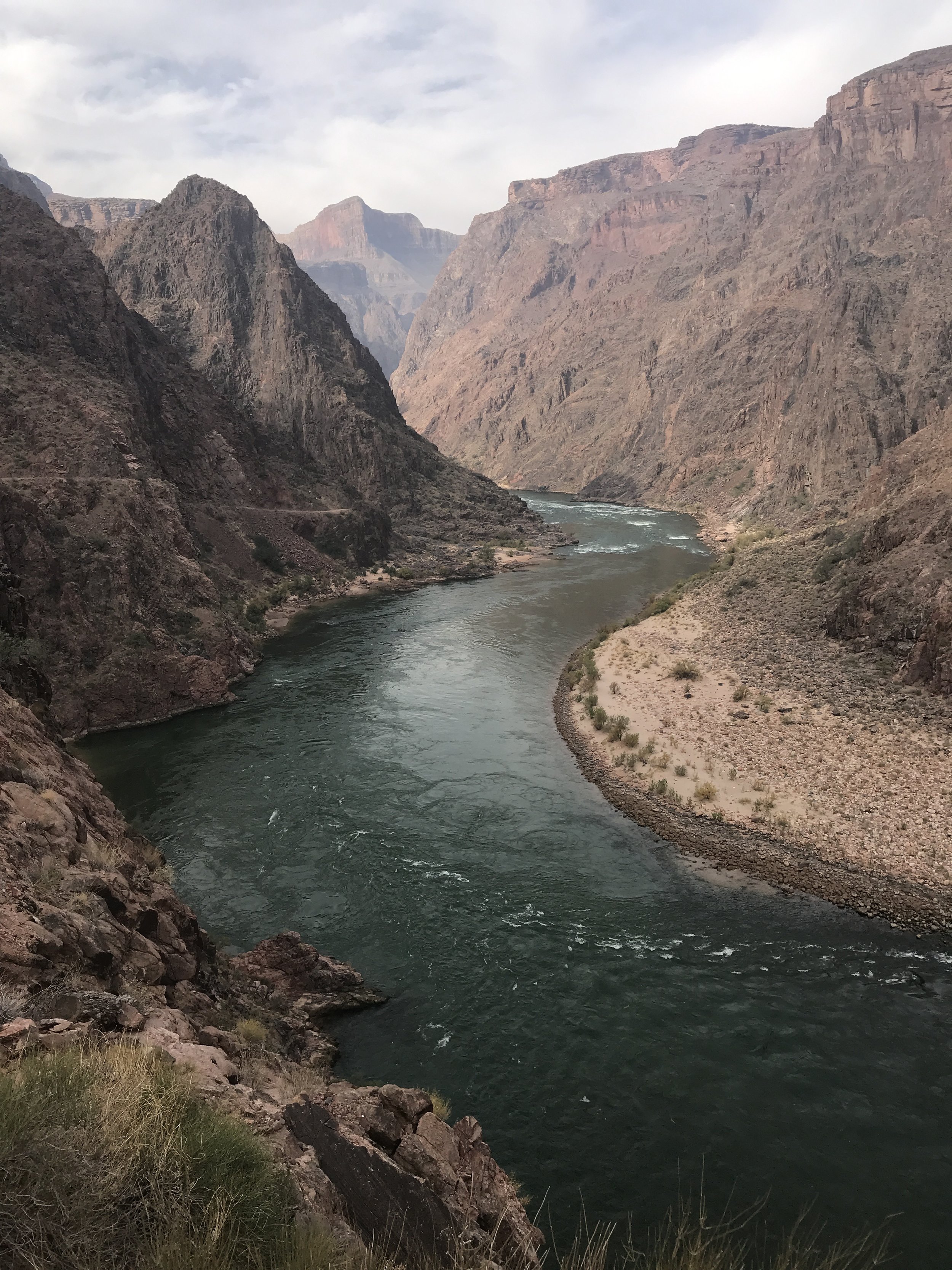
The mighty Colorado River flowing through the Grand Canyon

The mighty Colorado River flowing through the Grand Canyon

Views of the North Rim from South Rim

Views of the North Rim from South Rim

WHAT TO BRING:

  • Tennis shoes or a comfortable pair of hiking boots
  • Extra pairs of socks and appropriate clothing.
  • Tent, sleeping bag, sleeping pad
  • 4 liters of water (plus water filter)
  • Meals, snacks (GU Gels)
  • Jet Boil and matches if cooking meals
  • Headlight
  • Sunscreen
  • The list continues...remember that you are hiking around 50 miles so the lighter your pack the better.

* There is food and drink sold at the Lodges at both the South and North Rim. Food and drink is also sold at Phantom Ranch, a set of cottages at the bottom of the Canyon almost directly in between South and North Rim. I would check ahead to see if these locations are open before heading into the Canyon.

CAUTION:

As usual with these kind of hikes make sure that you take the time to prepare yourself. Tell someone else about your travel plans. Pack and prepare adequately, hydrate, and bring enough nutrition to power you through. If you have any questions I'd be happy to answer them. Happy hiking!

Wooden Shoe Tulip Festival

"A tulip doesn't strive to impress anyone. It doesn't struggle to be different than a rose. It doesn't have to. It is different." - Marianne Williamson

The fields are adorned with tulips of all variety and color at the Wooden Shoe Tulip Festival.

The fields are adorned with tulips of all variety and color at the Wooden Shoe Tulip Festival.

WHAT YOU'LL SEE

Tulips. Tulips. And more tulips. Row and rows of them. All shapes and sizes. All colors and varieties. It's all here. Bring friends, bring family and come wander through the fields. Buy some popcorn and take the kids on the giant slide. Come early and catch the sun rise over the snow caps of Mt. Hood. Watch the hot air balloons take off. Buy some tulips for your loved ones. Buy some seeds to plant in your yard. Peruse the local artisan booths. Enjoy wine tasting. And takes lots of pictures! That's what you'll get at the Wooden Shoe Tulip Festival. 

HISTORY

What started as a humble 15 acres in the 1980's has now transformed into a 40 acre field of tulips. Tulips are planted each October by three machines purchased from Holland. Meticulous measures are made to make sure the tulips are free of disease, weeds, insects and erosion. Every year a new variety of tulips are planted and arranged differently for people from all over the world to enjoy.

WHERE

Woodburn, Oregon. An hour south of Portland on the I-5. 

WHEN

Generally, the Festival runs from late March to late April/early May.

HOW MUCH

Admission to get into the Festival is $5/person or $20/car (if there are more than 4 people).

MORE INFORMATION

http://www.woodenshoe.com/events/tulip-fest/tickets/

IMG_4316.JPG

Coyote Gulch - Jacob Hamblin Arch

The massive and very impressive Jacob Hamblin Arch in Coyote Gulch.

The massive and very impressive Jacob Hamblin Arch in Coyote Gulch.

WHAT YOU'LL SEE

Within the Grand Escalante National Monument, America's biggest monument, is the winding river of Coyote Gulch. Along the river are several notable rock formations, with the most stunning of these being the Jacob Hamblin Arch, named after the western pioneer and peacemaker. The arch boasts its impressive size and shape over the tight canyon walls of Coyote Gulch, and in the spring the river is lined with bright green foliage.

A view looking East into Coyote Gulch from the top of Jacob Hamblin Arch

A view looking East into Coyote Gulch from the top of Jacob Hamblin Arch

HOW TO GET THERE

Access to the Jacob Hamblin Arch begins in Escalante, Utah just off the scenic byway 12, which will also take you to Bryce Canyon. Five miles east of Escalante on byway 12 is Hole in the Rock Road, a sixty two mile unpaved road that ends at Lake Powell. Although I did see small two wheel drive cars on the road, four wheel drive and high clearance is highly recommended. To access the Jacob Hamblin Arch trailhead take Hole in the Rock Road thirty six miles until you reach Fortymile Ridge Road. From there head east (left) another four miles until you reach a turnoff to the left. You will reach a water tank at the top of a small hill where you can park and sign in at the trailhead.

From the trailhead, plan on hiking two miles on a fairly well marked path with cairns in sand and slick rock. The trail will lead you down a steep but navigable entrance into Coyote Gulch. This approach can be tricky with a large pack so make sure to take your time or use the small rope attached to the rock at the top of the descent to help lead you down. 

A view from the top of Jacob Hamblin Arch before you start your descent into Coyote Gulch

A view from the top of Jacob Hamblin Arch before you start your descent into Coyote Gulch

Another view from the top

Another view from the top

Cairns leading the way to the Arch

Cairns leading the way to the Arch

These white "angel wings" will denote the area of descent into Coyote Gulch

These white "angel wings" will denote the area of descent into Coyote Gulch

Views from the JH trailhead

Views from the JH trailhead


WHAT TO EAT

As for as good eats around Escalante I would highly recommend Escalante Outfitters for a half meat lovers, half vegetarian pizza with a Polygamy Porter as a beverage. Escalante Outfitters also stocks great maps and information booklets about hikes in Southern Utah.


White Pocket

A hiker in White Pocket

A hiker in White Pocket

One of the most surreal landscapes in Arizona remains largely unknown to many native explorers. Perhaps it's because of the six hour round trip over a difficult 4 wheel drive, high clearance road filled with deep sand and jutting rock that makes this surreal location very difficult to get to. While The Wave gets most of the notoriety for the area, White Pocket stands as a diamond on its own. Filled with brilliant swirls of colors and textures, White Pocket is easily navigated within a half day. Camping is also offered at the trailhead - a short quarter mile hike to White Pocket. 

Colorful swirls and textures grace the landscape at White Pocket

Colorful swirls and textures grace the landscape at White Pocket

Give yourself at least a half day to explore 

Give yourself at least a half day to explore 

To get here take the 89A to House Rock Valley Road. Road maps are provided by the BLM Ranger Station in Kanab, Utah. Stop in at Jacob Lake on your way out for a bite to eat.